M3 - Learner Manual
5. Language and Tribal Boundaries
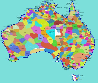
Figure 1: Map of Indigenous Tribal Groups in Australia
Created in 1994, the Aboriginal Australia map is an attempt to show the diversity of Australian Indigenous languages using sources available at the time. The information in the map is contested by some traditional landowners.
Source: https://aiatsis.gov.au/explore/articles/aiatsis-map-indigenous-australia
Today there are Aboriginal language centres and programs being developed to support keeping language and culture alive. In NSW, the Department of Aboriginal Affairs supports five Aboriginal Language and Culture Nests. These are:
· Bundjalung – East of (approximately) a line running from Grafton to the Qld boarder
· Gamilaraay/Yuwaalaraay – Area approximately bordered by Collarenebri, Walgett and Goodooga
· Gumbaynggirr – Mid NSW north coast – Area south of Grafton to Nambucca and inland to Dorrigo
· North West Wiradjuri – Areas around Dubbo – south to Peak Hill, east to Mudgee, North to Gilgandra and west to Trangie
· Paakantji/Baarkintji - includes the communities of Broken Hill, Wilcannia, Menindee, Bourke, Mildura and Coomealla.
You can access further information on each Nest at the following link:
https://www.aboriginalaffairs.nsw.gov.au/policy-reform/language-and-culture/nests
Consider the following question in preparation for your weekly Q&A sessions with your trainer:
Whilst there is a lot of discussion on the loss of Aboriginal and Torres Strait Islander verbal/oral language, are there other forms of language that Aboriginal and Torres Strait Islander people use?